Atlas
Where things are, and how well that is known
A curated and expanding set of spatial representations — 144 of them, covering 105 entities. This is not a geological map of Earth and does not claim to be one. Every representation is one published interpretation, at one scale, by one identified source, and each carries its own statement of how certain its boundary is.
What this atlas is not
- Not complete. Coverage follows source quality and explanatory value, not geography, and large parts of the world have no representation here at all.
- Not a bedrock geology map. Everything here is a plate model and its derived regions; no lithology, no crustal age and no structural mapping is included.
- Not a basis for locating anything. Nothing on this page ranks ground, scores a region, or assesses what may be present anywhere.
- Not more precise than its sources. A figure can be enlarged indefinitely; the evidence behind it cannot.
Figures
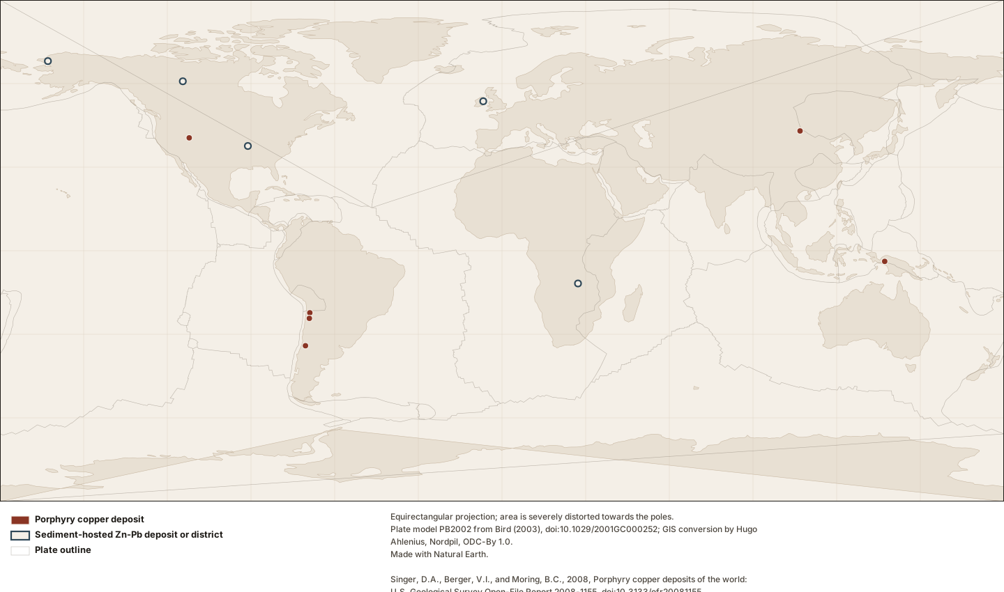
Figure by Lithoen. Plate model PB2002 from Bird (2003), doi:10.1029/2001GC000252; GIS conversion by Hugo Ahlenius, Nordpil, ODC-By 1.0. Made with Natural Earth. Singer, D.A., Berger, V.I., and Moring, B.C., 2008, Porphyry copper deposits of the world: U.S. Geological Survey Open-File Report 2008-1155, doi:10.3133/ofr20081155. Singer, D.A., Berger, V.I., and Moring, B.C., 2009, Sediment-hosted zinc-lead deposits of the world: U.S. Geological Survey Open-File Report 2009-1252, doi:10.3133/ofr20091252. Underlying data remain under their own licences. · LITHOEN-ORIGINAL · Derivative: Generated from published Lithoen spatial records by scripts/generate-maps.ts; no coordinate was edited by hand. Deposit symbols are drawn at a fixed radius. No quantity is encoded in symbol size, because the tonnage figures available are compiler totals whose definitions differ between the two databases and are not comparable with one another.
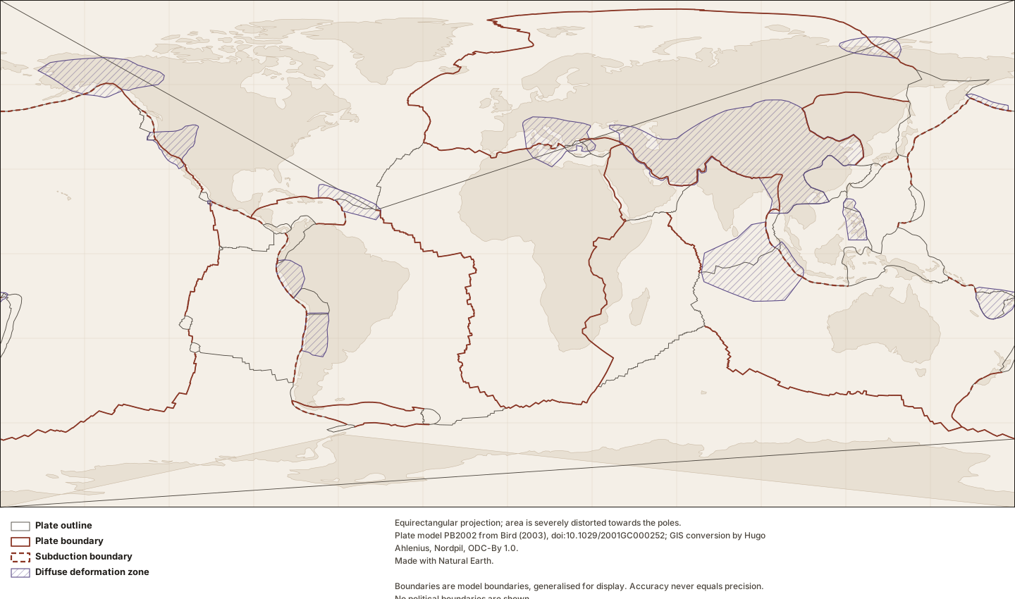
Figure by Lithoen. Plate model PB2002 from Bird (2003), doi:10.1029/2001GC000252; GIS conversion by Hugo Ahlenius, Nordpil, ODC-By 1.0. Made with Natural Earth. Underlying data remain under their own licences. · LITHOEN-ORIGINAL · Derivative: Generated from published Lithoen spatial records by scripts/generate-maps.ts; no coordinate was edited by hand. Features spanning ±180° are split for rendering only; the stored geometry is unchanged.
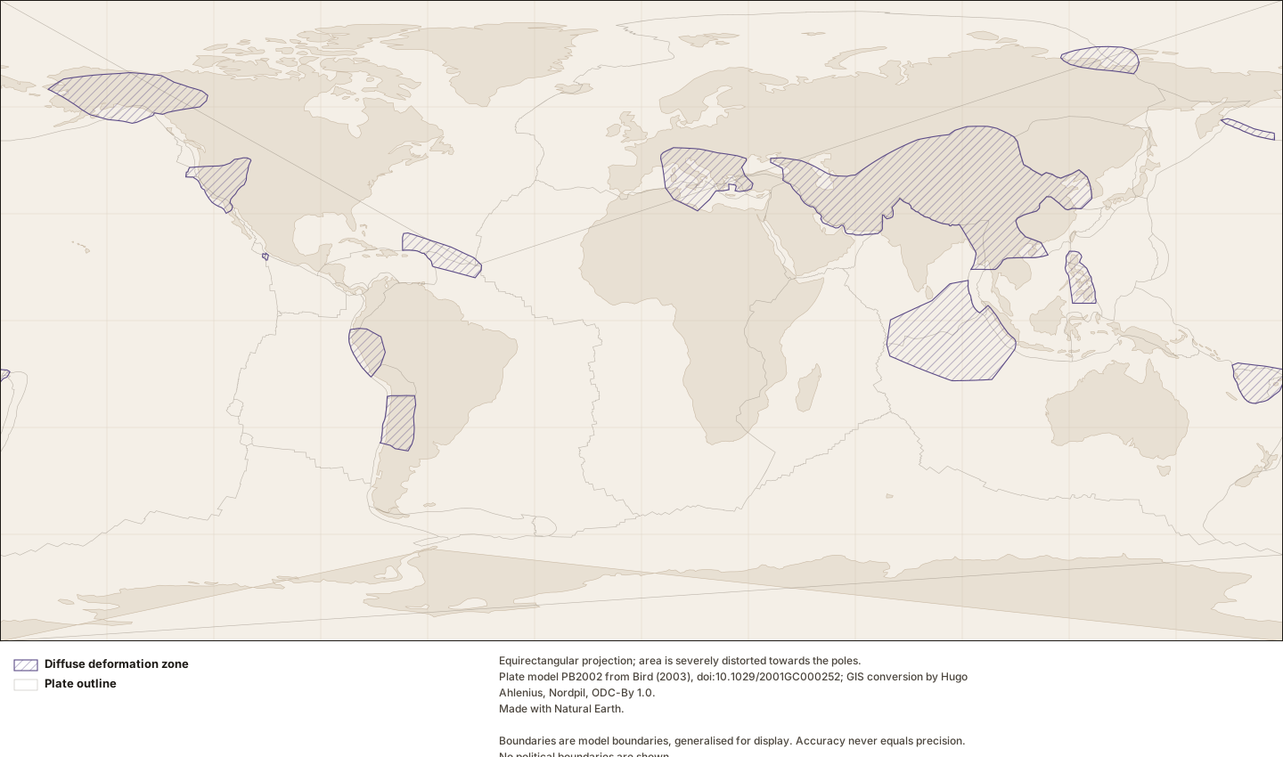
Figure by Lithoen. Plate model PB2002 from Bird (2003), doi:10.1029/2001GC000252; GIS conversion by Hugo Ahlenius, Nordpil, ODC-By 1.0. Made with Natural Earth. Underlying data remain under their own licences. · LITHOEN-ORIGINAL · Derivative: Generated from published Lithoen spatial records by scripts/generate-maps.ts; no coordinate was edited by hand. Features spanning ±180° are split for rendering only; the stored geometry is unchanged.
Reading the records
What a geometry means
- Published interpretive extent
- An extent published by an identified author or group as their interpretation. It is citable, reproducible and attributable, and it is one reading rather than the reading. Most extents in a geological corpus are this.
- Boundary
- A line delimiting or separating things — a plate boundary, a suture, a mapped contact. A boundary is not an extent: it says where the edge runs, not what lies on either side.
- Representative point
- A single position standing for something that is not a point. It exists so a feature can be shown on a map or listed by location, and it asserts NOTHING about extent. A representative point for a 2,000 km province is a label anchor, not a location.
- Tectonic model geometry
- Geometry that exists because a model defines it — a rigid-plate outline, a zone where a model declares itself inapplicable. It is a property of the model, and changes when the model is revised. It is present-day geometry from a present-day model; a palaeogeographic reconstruction is a different thing and Lithoen does not hold one.
How certain an edge is
- Defined
- The boundary is fixed by a definition rather than found in the field — a model boundary, a stated coordinate limit, an administrative extent of a survey. It is exactly where it says it is, because it is a definition.
- Interpreted
- The boundary was placed by a geologist reading evidence: mapping, geophysics, geochronology, structure. It is reproducible from that evidence and it is an interpretation of it. Most geological boundaries are this.
- Approximate
- The position is known only within a distance much larger than the line width on any map that shows it. Drawing it thinner does not make it better known.
Every representation
The complete list, and the non-visual equivalent of the figures above. Nothing on this page exists only inside an image.
| Entity | Type | Geometry means | Boundary | Status | Positions |
|---|---|---|---|---|---|
| Aitik | Deposit | Representative point | Approximate | inferred | 1 |
| Ashele | Deposit | Representative point | Approximate | inferred | 1 |
| Beatson | Deposit | Representative point | Approximate | inferred | 1 |
| Bhimatangar | Deposit | Representative point | Approximate | inferred | 1 |
| Bingham Canyon | Deposit | Representative point | Approximate | inferred | 1 |
| Bjurliden | Deposit | Representative point | Approximate | inferred | 1 |
| Bulong | Deposit | Representative point | Approximate | inferred | 1 |
| Buruktal | Deposit | Representative point | Approximate | inferred | 1 |
| Çalda? | Deposit | Representative point | Approximate | inferred | 1 |
| Caleta Coloso | Deposit | Representative point | Approximate | inferred | 1 |
| Cawse | Deposit | Representative point | Approximate | inferred | 1 |
| Cerro Matoso | Deposit | Representative point | Approximate | inferred | 1 |
| Chuquicamata | Deposit | Representative point | Approximate | inferred | 1 |
| Corocoro | Deposit | Representative point | Approximate | inferred | 1 |
| Dzhezkazgan | Deposit | Representative point | Approximate | inferred | 1 |
| El Teniente | Deposit | Representative point | Approximate | inferred | 1 |
| Ellamar | Deposit | Representative point | Approximate | inferred | 1 |
| Escondida | Deposit | Representative point | Approximate | inferred | 1 |
| Estaçao | Deposit | Representative point | Approximate | inferred | 1 |
| Gacun | Deposit | Representative point | Approximate | inferred | 1 |
| Grasberg | Deposit | Representative point | Approximate | inferred | 1 |
| Greenvale | Deposit | Representative point | Approximate | inferred | 1 |
| Kennecott | Deposit | Representative point | Approximate | inferred | 1 |
| Khandiza | Deposit | Representative point | Approximate | inferred | 1 |
| Kipushi | Deposit | Representative point | Approximate | inferred | 1 |
| Konrad | Deposit | Representative point | Approximate | inferred | 1 |
| Kosaka (Uchinotai-Uwamuki) | Deposit | Representative point | Approximate | inferred | 1 |
| Las Vigas | Deposit | Representative point | Approximate | inferred | 1 |
| Lubin | Deposit | Representative point | Approximate | inferred | 1 |
| Madneuli | Deposit | Representative point | Approximate | inferred | 1 |
| Maleevskoe | Deposit | Representative point | Approximate | inferred | 1 |
| Marlborough | Deposit | Representative point | Approximate | inferred | 1 |
| Moa | Deposit | Representative point | Approximate | inferred | 1 |
| Murrin Murrin | Deposit | Representative point | Approximate | established | 1 |
| Navan | Deposit | Representative point | Approximate | inferred | 1 |
| Neves-Corvo | Deposit | Representative point | Approximate | inferred | 1 |
| Nicaro | Deposit | Representative point | Approximate | inferred | 1 |
| Nkamouna | Deposit | Representative point | Approximate | inferred | 1 |
| Novo-Berezovskoe | Deposit | Representative point | Approximate | inferred | 1 |
| Ora Banda | Deposit | Representative point | Approximate | inferred | 1 |
| Oyu Tolgoi | Deposit | Representative point | Approximate | inferred | 1 |
| Ozernoe | Deposit | Representative point | Approximate | inferred | 1 |
| Pine Point | Deposit | Representative point | Approximate | inferred | 1 |
| Punta Gorda | Deposit | Representative point | Approximate | inferred | 1 |
| Pyke Hill | Deposit | Representative point | Approximate | established | 1 |
| Ravensthorpe | Deposit | Representative point | Approximate | inferred | 1 |
| Red Dog | Deposit | Representative point | Approximate | inferred | 1 |
| Richelsdorf | Deposit | Representative point | Approximate | inferred | 1 |
| Ridder-Sokolnoe | Deposit | Representative point | Approximate | inferred | 1 |
| Rio Tinto | Deposit | Representative point | Approximate | inferred | 1 |
| Rock Creek | Deposit | Representative point | Approximate | inferred | 1 |
| Ržanovo | Deposit | Representative point | Approximate | inferred | 1 |
| San Romeleo | Deposit | Representative point | Approximate | inferred | 1 |
| Serovskoe | Deposit | Representative point | Approximate | inferred | 1 |
| Soroako | Deposit | Representative point | Approximate | inferred | 1 |
| Spar Lake | Deposit | Representative point | Approximate | disputed | 1 |
| Tarnyerskoe | Deposit | Representative point | Approximate | inferred | 1 |
| Tashiro | Deposit | Representative point | Approximate | inferred | 1 |
| Vihanti | Deposit | Representative point | Approximate | inferred | 1 |
| Vuonos | Deposit | Representative point | Approximate | inferred | 1 |
| Whim Creek | Deposit | Representative point | Approximate | inferred | 1 |
| Wingellina | Deposit | Representative point | Approximate | inferred | 1 |
| Witvlei | Deposit | Representative point | Approximate | inferred | 1 |
| Xiaorequanzi | Deposit | Representative point | Approximate | inferred | 1 |
| Yokota (Motoyama-Hama) | Deposit | Representative point | Approximate | inferred | 1 |
| Zolotushinskoe | Deposit | Representative point | Approximate | inferred | 1 |
| Alaska–Yukon diffuse deformation zone | Geological region | Tectonic model geometry | Defined | modelled | 65 |
| Alps diffuse deformation zone | Geological region | Tectonic model geometry | Defined | modelled | 80 |
| Gorda–California–Nevada diffuse deformation zone | Geological region | Tectonic model geometry | Defined | modelled | 82 |
| Laptev Sea diffuse deformation zone | Geological region | Tectonic model geometry | Defined | modelled | 28 |
| New Hebrides–Fiji diffuse deformation zone | Geological region | Tectonic model geometry | Defined | modelled | 152 |
| Ninetyeast–Sumatra diffuse deformation zone | Geological region | Tectonic model geometry | Defined | modelled | 126 |
| Persia–Tibet–Burma diffuse deformation zone | Geological region | Tectonic model geometry | Defined | modelled | 315 |
| Peru diffuse deformation zone | Geological region | Tectonic model geometry | Defined | modelled | 50 |
| Philippines diffuse deformation zone | Geological region | Tectonic model geometry | Defined | modelled | 59 |
| Puna–Sierras Pampeanas diffuse deformation zone | Geological region | Tectonic model geometry | Defined | modelled | 56 |
| Rivera–Cocos diffuse deformation zone | Geological region | Tectonic model geometry | Defined | modelled | 14 |
| Viburnum Trend | Geological region | Representative point | Approximate | inferred | 1 |
| West-central Atlantic diffuse deformation zone | Geological region | Tectonic model geometry | Defined | modelled | 74 |
| Western Aleutians diffuse deformation zone | Geological region | Tectonic model geometry | Defined | modelled | 36 |
| Yilgarn Craton | Geological region | Published interpretive extent | Interpreted | inferred | 243 |
| African Plate | Tectonic plate | Tectonic model geometry | Interpreted | modelled | 431 |
| African Plate | Tectonic plate | Boundary | Interpreted | modelled | 72 |
| African Plate | Tectonic plate | Boundary | Interpreted | modelled | 51 |
| African Plate | Tectonic plate | Boundary | Interpreted | modelled | 164 |
| African Plate | Tectonic plate | Boundary | Interpreted | modelled | 29 |
| African Plate | Tectonic plate | Boundary | Interpreted | modelled | 125 |
| African Plate | Tectonic plate | Boundary | Interpreted | modelled | 258 |
| Altiplano Plate | Tectonic plate | Tectonic model geometry | Interpreted | modelled | 23 |
| Altiplano Plate | Tectonic plate | Boundary | Interpreted | modelled | 13 |
| Amur Plate | Tectonic plate | Tectonic model geometry | Interpreted | modelled | 71 |
| Amur Plate | Tectonic plate | Boundary | Interpreted | modelled | 94 |
| Amur Plate | Tectonic plate | Boundary | Interpreted | modelled | 17 |
| Anatolian Plate | Tectonic plate | Tectonic model geometry | Interpreted | modelled | 33 |
| Anatolian Plate | Tectonic plate | Boundary | Interpreted | modelled | 25 |
| Antarctic Plate | Tectonic plate | Tectonic model geometry | Interpreted | modelled | 388 |
| Antarctic Plate | Tectonic plate | Boundary | Interpreted | modelled | 209 |
| Antarctic Plate | Tectonic plate | Boundary | Interpreted | modelled | 302 |
| Antarctic Plate | Tectonic plate | Boundary | Interpreted | modelled | 34 |
| Antarctic Plate | Tectonic plate | Boundary | Interpreted | modelled | 17 |
| Arabian Plate | Tectonic plate | Tectonic model geometry | Interpreted | modelled | 113 |
| Arabian Plate | Tectonic plate | Boundary | Interpreted | modelled | 13 |
| Arabian Plate | Tectonic plate | Boundary | Interpreted | modelled | 53 |
| Australian Plate | Tectonic plate | Tectonic model geometry | Interpreted | modelled | 343 |
| Australian Plate | Tectonic plate | Boundary | Interpreted | modelled | 76 |
| Australian Plate | Tectonic plate | Boundary | Interpreted | modelled | 143 |
| Australian Plate | Tectonic plate | Boundary | Interpreted | modelled | 51 |
| Burma Plate | Tectonic plate | Tectonic model geometry | Interpreted | modelled | 36 |
| Burma Plate | Tectonic plate | Boundary | Interpreted | modelled | 9 |
| Burma Plate | Tectonic plate | Boundary | Interpreted | modelled | 22 |
| Caribbean Plate | Tectonic plate | Tectonic model geometry | Interpreted | modelled | 75 |
| Caribbean Plate | Tectonic plate | Boundary | Interpreted | modelled | 9 |
| Caribbean Plate | Tectonic plate | Boundary | Interpreted | modelled | 53 |
| Caribbean Plate | Tectonic plate | Boundary | Interpreted | modelled | 22 |
| Caribbean Plate | Tectonic plate | Boundary | Interpreted | modelled | 24 |
| Cocos Plate | Tectonic plate | Tectonic model geometry | Interpreted | modelled | 71 |
| Cocos Plate | Tectonic plate | Boundary | Interpreted | modelled | 35 |
| Cocos Plate | Tectonic plate | Boundary | Interpreted | modelled | 39 |
| Eurasian Plate | Tectonic plate | Tectonic model geometry | Interpreted | modelled | 404 |
| Eurasian Plate | Tectonic plate | Boundary | Interpreted | modelled | 95 |
| Eurasian Plate | Tectonic plate | Boundary | Interpreted | modelled | 569 |
| Indian Plate | Tectonic plate | Tectonic model geometry | Interpreted | modelled | 167 |
| Indian Plate | Tectonic plate | Boundary | Interpreted | modelled | 85 |
| Juan de Fuca Plate | Tectonic plate | Tectonic model geometry | Interpreted | modelled | 56 |
| Juan de Fuca Plate | Tectonic plate | Boundary | Interpreted | modelled | 53 |
| Nazca Plate | Tectonic plate | Tectonic model geometry | Interpreted | modelled | 215 |
| Nazca Plate | Tectonic plate | Boundary | Interpreted | modelled | 108 |
| Nazca Plate | Tectonic plate | Boundary | Interpreted | modelled | 62 |
| North American Plate | Tectonic plate | Tectonic model geometry | Interpreted | modelled | 395 |
| North American Plate | Tectonic plate | Boundary | Interpreted | modelled | 127 |
| North American Plate | Tectonic plate | Boundary | Interpreted | modelled | 106 |
| North Andes Plate | Tectonic plate | Tectonic model geometry | Interpreted | modelled | 62 |
| North Andes Plate | Tectonic plate | Boundary | Interpreted | modelled | 34 |
| Okhotsk Plate | Tectonic plate | Tectonic model geometry | Interpreted | modelled | 66 |
| Okhotsk Plate | Tectonic plate | Boundary | Interpreted | modelled | 70 |
| Pacific Plate | Tectonic plate | Tectonic model geometry | Interpreted | modelled | 507 |
| Pacific Plate | Tectonic plate | Boundary | Interpreted | modelled | 30 |
| Philippine Sea Plate | Tectonic plate | Tectonic model geometry | Interpreted | modelled | 112 |
| Scotia Plate | Tectonic plate | Tectonic model geometry | Interpreted | modelled | 76 |
| Somali Plate | Tectonic plate | Tectonic model geometry | Interpreted | modelled | 265 |
| South American Plate | Tectonic plate | Tectonic model geometry | Interpreted | modelled | 320 |
| South American Plate | Tectonic plate | Boundary | Interpreted | modelled | 47 |
| Sunda Plate | Tectonic plate | Tectonic model geometry | Interpreted | modelled | 105 |
| Yangtze Plate | Tectonic plate | Tectonic model geometry | Interpreted | modelled | 59 |
Where the geometry comes from
- Sediment-hosted copper deposits of the world (USGS OFR 03-107)
- Cox, D.P., Lindsey, D.A., Singer, D.A., Moring, B.C., and Diggles, M.F., 2003, Sediment-hosted copper deposits of the world: Deposit models and database: U.S. Geological Survey Open-File Report 03-107, doi:10.3133/ofr03107.
- Volcanogenic massive sulfide deposits of the world (USGS OFR 2009-1034)
- Mosier, D.L., Berger, V.I., and Singer, D.A., 2009, Volcanogenic massive sulfide deposits of the world: Database and grade and tonnage models: U.S. Geological Survey Open-File Report 2009-1034, doi:10.3133/ofr20091034.
- Ni-Co laterite deposits of the world (USGS OFR 2011-1058)
- Berger, V.I., Singer, D.A., Bliss, J.D., and Moring, B.C., 2011, Ni-Co laterite deposits of the world: Database and grade and tonnage models: U.S. Geological Survey Open-File Report 2011-1058, doi:10.3133/ofr20111058.
- Porphyry copper deposits of the world (USGS OFR 2008-1155)
- Singer, D.A., Berger, V.I., and Moring, B.C., 2008, Porphyry copper deposits of the world: U.S. Geological Survey Open-File Report 2008-1155, doi:10.3133/ofr20081155.
- Sediment-hosted zinc-lead deposits of the world (USGS OFR 2009-1252)
- Singer, D.A., Berger, V.I., and Moring, B.C., 2009, Sediment-hosted zinc-lead deposits of the world: U.S. Geological Survey Open-File Report 2009-1252, doi:10.3133/ofr20091252.
- PB2002 plates, boundaries and orogens as GeoJSON (fraxen/tectonicplates)
- Plate model PB2002 from Bird (2003), doi:10.1029/2001GC000252; GIS conversion by Hugo Ahlenius, Nordpil, ODC-By 1.0.
- Australian Geological Provinces — Archean to Proterozoic tectonic provinces (layer 20)
- © Commonwealth of Australia (Geoscience Australia) 2018, CC BY 4.0. Australian Geological Provinces Database, edition 2013.01.
Coastlines are drawn from Natural Earth, which its authors place in the public domain. No political boundary appears on any Lithoen map: political geography is not the subject here, and border styling would imply editorial positions Lithoen does not hold.
Figures are pre-rendered and carry no map library, no tiles and no external request. See how Lithoen knows what it knows for the epistemic model these records use.