Each claim states how it is known and cites its evidence.
EstablishedODC-By 1.0: derivatives permitted, attribution required, and carried into every derived figure.
A property of a dataset or model, shown here for context — not an observation about this record.
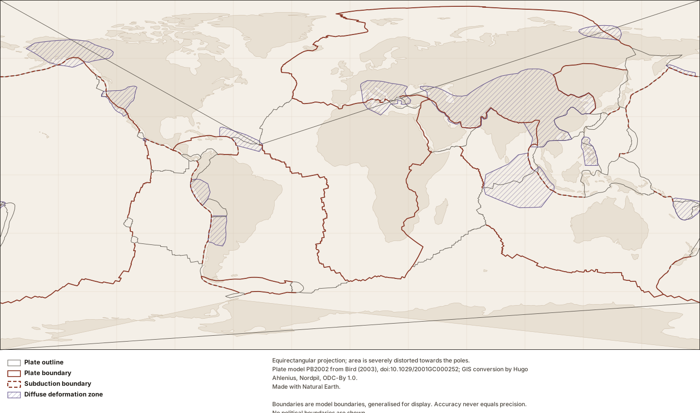
Every plate geometry Lithoen publishes is derived from a conversion of model PB2002 made available under the Open Data Commons Attribution License 1.0, which permits derivative publication and requires attribution. The repository asks that Hugo Ahlenius, Nordpil and Peter Bird be credited, and Lithoen renders that credit wherever a derivative appears — including on maps it draws itself, because drawing a map from someone else’s data does not make the data Lithoen’s.
- definition basis: The licence was read in LICENSE.md and in the repository README on the date recorded on dataset:pb2002-tectonicplates-geojson.
- precision note: The original PB2002 files on the author’s own site carry no licence at all. Lithoen therefore derives geometry only from the explicitly licensed conversion, and cites the original model as the source of the science.
- generality: DATASET_PROPERTY
Evidence support: Supported by the cited evidence · one source
Evidence: Ahlenius 2014 · Peer-reviewed
EstablishedThe dateline split is the converter’s edit, disclosed and attributed, not Lithoen’s and not the Earth’s.
A property of a dataset or model, shown here for context — not an observation about this record.
Four plates arrive from the conversion already split at ±180°, because the converter states that the main edits it made "regarded segments spanning the -180/180 boundary, which had to be manually split and moved". Lithoen records that as an inherited transformation on every affected geometry rather than presenting the split as its own, and never reports it as evidence that a plate is in pieces.
- precision note: A transformation nobody performed on Lithoen’s side is still a transformation between the Earth and the reader, and disclosing only one’s own edits would misrepresent the chain.
- generality: DATASET_PROPERTY
Evidence support: Supported by the cited evidence · one source
Evidence: Ahlenius 2014 · Peer-reviewed
EstablishedPrecision is a property of the number; accuracy is a property of the knowledge.
General principle, shown here for context — not an observation about this record.
A coordinate can be precise and wrong. Bird’s own documentation for model PB2002 gives every point to six significant digits, so that round-off error in position does not exceed 60 metres, and then states plainly: "accuracy never equals precision." The number of decimal places a boundary is stored to says nothing about how well anybody knows where it is.
- precision note: The controlling claim of the Phase 4 spatial layer. Every geometry Lithoen publishes carries a boundary certainty and an epistemic status of its own precisely because the coordinates cannot carry them.
- generality: GENERAL_PRINCIPLE
Evidence support: Supported by the cited evidence · one source
Evidence: Bird 2003 · Primary authority
EstablishedNorthwesterly motion relative to the North American Plate along the San Andreas fault zone.
Along the San Andreas fault zone, land on the Pacific Plate moves in a northwesterly direction relative to land on the North American Plate.
- reference frame: Relative to the North American Plate.
- locality: Along the San Andreas fault zone.
Evidence support: Supported by the cited evidence · one source
Evidence: Kious 1996 · Primary authority
EstablishedSUB, plus OSR, OTF, OCB, CRB, CTF and CCB from setting and relative velocity.
A property of a dataset or model, shown here for context — not an observation about this record.
PB2002 recognises seven classes of plate boundary step. Subduction requires a convergent velocity component together with a Benioff zone of intermediate to deep earthquakes and/or a parallel volcanic arc with Quaternary activity — criteria which, the author notes, exclude the Alps, Zagros, Pamirs, Himalaya, Tien Shan and Taiwan. The other six combine oceanic or continental setting with divergent, strike-slip or convergent motion.
- precision note: The exclusions matter more than the classes. Convergence across the Himalaya is not in doubt; what the criteria exclude is the label, because there is no Benioff zone and no Quaternary arc there.
- generality: DATASET_PROPERTY
Evidence support: Supported by the cited evidence · one source
Evidence: Bird 2003 · Primary authority
EstablishedBoundary class varies along a boundary, so a boundary has no single class.
A property of a dataset or model, shown here for context — not an observation about this record.
A single class cannot always be specified for an entire plate boundary curve, or even for an entire segment, because the class changes with local changes in the azimuth of the boundary; relative velocities change smoothly in magnitude and azimuth along every boundary.
- precision note: Lithoen therefore labels a boundary geometry as subduction only where the source does, and classifies no further. Where the source declines to classify, so does the corpus.
- generality: DATASET_PROPERTY
Evidence support: Supported by the cited evidence · one source
Evidence: Bird 2003 · Primary authority
Established52 plates, 229 boundary segments, 13 orogens.
A property of a dataset or model, shown here for context — not an observation about this record.
Model PB2002 comprises plate boundary curves in 229 segments, 52 plates given as closed counterclockwise outlines, and 13 orogens given as outlines with spelled-out names, chosen — the author writes — to help prevent confusion between orogens and plates.
- generality: DATASET_PROPERTY
Evidence support: Supported by the cited evidence · one source
Evidence: Bird 2003 · Primary authority
EstablishedBoundary segments carry individual source credits within the model.
A property of a dataset or model, shown here for context — not an observation about this record.
The segments of PB2002 are individually credited: different parts of a single plate boundary may be attributed to different sources, and the model records those attributions in its segment titles.
- precision note: Lithoen carries each segment’s credit into the caption of the geometry derived from it, so that merging segments for display never erases who drew them.
- generality: DATASET_PROPERTY
Evidence support: Supported by the cited evidence · one source
Evidence: Bird 2003 · Primary authority
EstablishedEvery plate boundary Lithoen shows belongs to a named, dated, citable model.
General principle, shown here for context — not an observation about this record.
A plate boundary is a line in a model. PB2002 is one such model, published in 2003, dividing Earth into 52 plates; other models divide it differently, and a boundary’s position, its class and even its existence depend on which model is being read. Lithoen names the model on every plate geometry it publishes and never draws an unattributed boundary.
- model: PB2002, from Bird (2003), doi:10.1029/2001GC000252.
- generality: GENERAL_PRINCIPLE
Evidence support: Supported by the cited evidence · 2 sources, multiple sources, one origin
Evidence: Bird 2003 · Primary authority; Bird 2003 · Primary authority
EstablishedPlates are lithospheric, not geographic; 52 of them, and 13 regions where the model fails.
General principle, shown here for context — not an observation about this record.
A plate is not a continent. Model PB2002 divides Earth into 52 plates, most of which are dominantly oceanic, several of which carry parts of two continents, and several of which carry no continent at all. It also marks 13 regions where no rigid plate describes the motion.
- generality: GENERAL_PRINCIPLE
Evidence support: Supported by the cited evidence · one source
Evidence: Bird 2003 · Primary authority