An oceanic plate of the eastern Pacific that is being subducted beneath the South American Plate along the Peru–Chile trench, driving Andean uplift and seismicity.
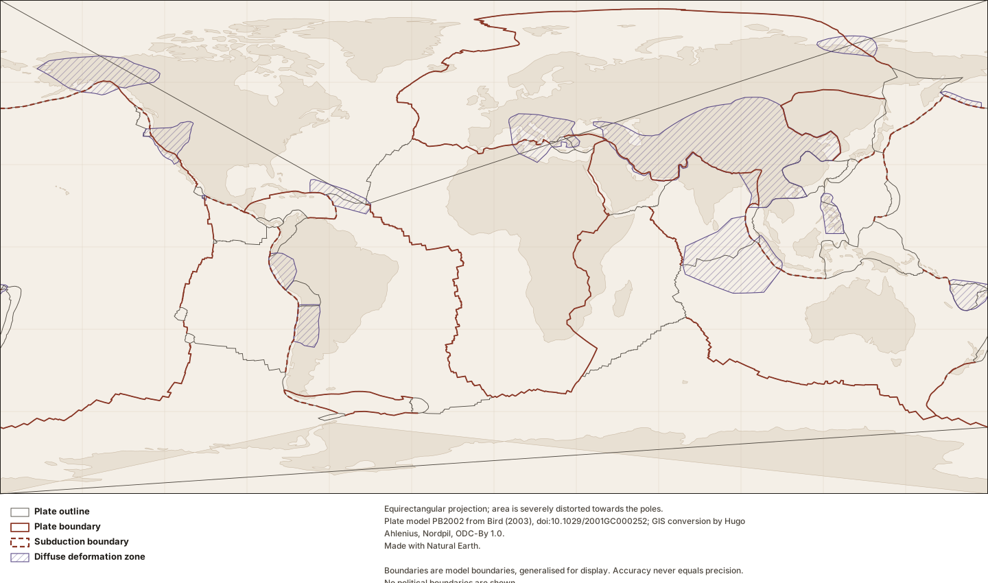
Twenty-four tectonic plates as outlined in model PB2002 (Bird, 2003), with the boundary curves Lithoen holds for them and the thirteen regions the model calls orogens. Every line here is a model boundary rather than a mapped geological contact: the model is a compilation from published sources at varying scales, its author states that accuracy never equals precision, and boundary class changes along a boundary — so only the segments the source labels subduction are shown as such. Outlines are generalised for display at a recorded tolerance. Areas near the poles are severely exaggerated by the projection, which is stated on the figure.
Figure by Lithoen. Plate model PB2002 from Bird (2003), doi:10.1029/2001GC000252; GIS conversion by Hugo Ahlenius, Nordpil, ODC-By 1.0. Made with Natural Earth. Underlying data remain under their own licences. · LITHOEN-ORIGINAL · Derivative: Generated from published Lithoen spatial records by scripts/generate-maps.ts; no coordinate was edited by hand. Features spanning ±180° are split for rendering only; the stored geometry is unchanged.
Classification
plate class
major
How this is mapped
3 published representations of where Nazca Plate is. Each is one interpretation, by one identified source, at one scale — not the shape of the thing itself.
Tectonic model geometry
Polygon · 215 positionspreferred for publication
Geometry that exists because a model defines it — a rigid-plate outline, a zone where a model declares itself inapplicable. It is a property of the model, and changes when the model is revised. It is present-day geometry from a present-day model; a palaeogeographic reconstruction is a different thing and Lithoen does not hold one.
The Nazca Plate as outlined in model PB2002 (Bird, 2003). This is the model’s boundary, not a mapped geological contact: it is where a rigid-plate model puts the edge of a plate, and Bird’s own documentation states that coordinates are given to a precision of about 60 m while "accuracy never equals precision". Where deformation is distributed rather than confined to a line, the model marks the region as an orogen and the outline there is a convenience.
Boundary certainty
InterpretedThe boundary was placed by a geologist reading evidence: mapping, geophysics, geochronology, structure. It is reproducible from that evidence and it is an interpretation of it. Most geological boundaries are this.
Status of this geometry
modelledThe status of the geometry, which need not match the status of what the entity’s claims assert.
Dataset
PB2002 plates, boundaries and orogens as GeoJSON (fraxen/tectonicplates)Plate model PB2002 from Bird (2003), doi:10.1029/2001GC000252; GIS conversion by Hugo Ahlenius, Nordpil, ODC-By 1.0.
What was done to this geometry
By Lithoen — Douglas–Peucker, 431 positions to 215
By Lithoen — Coordinates rounded to 4 decimal places, about 11 m of longitude at the equator.
Before it reached Lithoen — Bird (2003) digitised the boundary curves from published sources at varying scales; the model is a compilation, not a single survey.
Before it reached Lithoen — The GIS conversion (Ahlenius, ODC-By 1.0) split segments spanning the -180/180 meridian and moved them, as its README states. Four plates therefore arrive as multi-part geometries.
Boundary
MultiLineString · 108 positions
A line delimiting or separating things — a plate boundary, a suture, a mapped contact. A boundary is not an extent: it says where the edge runs, not what lies on either side.
Nazca–Pacific boundary as drawn in model PB2002 (Bird, 2003), from source segments NZ-PA. The East Pacific Rise, the fastest-spreading ridge on Earth and the setting in which black smoker vents were first found in 1979. The model applies no class to these segments. Bird states that a single class cannot always be specified for an entire boundary curve, or even for an entire segment, because the class changes with local changes in azimuth — so Lithoen classifies no further than the source does. Digitised by: Hey et al. [1995]; Lonsdale [1988]; Mueller et al. [1987]; Naar and Hey [1991].
Boundary certainty
InterpretedThe boundary was placed by a geologist reading evidence: mapping, geophysics, geochronology, structure. It is reproducible from that evidence and it is an interpretation of it. Most geological boundaries are this.
Status of this geometry
modelledThe status of the geometry, which need not match the status of what the entity’s claims assert.
Dataset
PB2002 plates, boundaries and orogens as GeoJSON (fraxen/tectonicplates)Plate model PB2002 from Bird (2003), doi:10.1029/2001GC000252; GIS conversion by Hugo Ahlenius, Nordpil, ODC-By 1.0.
What was done to this geometry
By Lithoen — 3 source features carrying the same identifier were combined into one multi-part geometry; no coordinate was altered by the combination.
By Lithoen — Coordinates rounded to 4 decimal places, about 11 m of longitude at the equator.
Before it reached Lithoen — Bird (2003) compiled these curves from published sources at varying scales, crediting each segment to its own source; those credits are carried in the caption of every record.
Before it reached Lithoen — The GIS conversion (Ahlenius, ODC-By 1.0) split segments spanning the -180/180 meridian and moved them, as its README states.
Boundary
MultiLineString · 62 positions
A line delimiting or separating things — a plate boundary, a suture, a mapped contact. A boundary is not an extent: it says where the edge runs, not what lies on either side.
Nazca–South American boundary as drawn in model PB2002 (Bird, 2003), from source segments NZ\SA. The Peru–Chile trench, where the Nazca Plate descends beneath South America. The Andes above it are the product; the trench is where the descent begins. The model labels these segments as subduction. Digitised by: by Peter Bird, 1999.
Boundary certainty
InterpretedThe boundary was placed by a geologist reading evidence: mapping, geophysics, geochronology, structure. It is reproducible from that evidence and it is an interpretation of it. Most geological boundaries are this.
Status of this geometry
modelledThe status of the geometry, which need not match the status of what the entity’s claims assert.
Dataset
PB2002 plates, boundaries and orogens as GeoJSON (fraxen/tectonicplates)Plate model PB2002 from Bird (2003), doi:10.1029/2001GC000252; GIS conversion by Hugo Ahlenius, Nordpil, ODC-By 1.0.
What was done to this geometry
By Lithoen — 2 source features carrying the same identifier were combined into one multi-part geometry; no coordinate was altered by the combination.
By Lithoen — Coordinates rounded to 4 decimal places, about 11 m of longitude at the equator.
Before it reached Lithoen — Bird (2003) compiled these curves from published sources at varying scales, crediting each segment to its own source; those credits are carried in the caption of every record.
Before it reached Lithoen — The GIS conversion (Ahlenius, ODC-By 1.0) split segments spanning the -180/180 meridian and moved them, as its README states.
How this record is known
1
Settled consensus
Cited as the accepted position of the discipline.
1 of 1 claims on this page cite at least one registered source. Counts describe how each statement is known, not how likely it is to be true.
What Lithoen records
Each claim states how it is known and cites its evidence.
EstablishedOceanic–continental convergence with the Nazca Plate descending.
Along the Peru–Chile trench the oceanic Nazca Plate is pushing into and being subducted beneath the continental part of the South American Plate.
Evidence support: Supported by the cited evidence· one source