Each claim states how it is known and cites its evidence.
InferredContext describes where systems have been found. It predicts nothing about a place.
A documented tectonic context is a statement about where a class of system has been found, not a statement about where one exists. Every setting recorded in this corpus is vastly more extensive than the systems found in it, several systems occur across settings with nothing in common, and one — nickel-cobalt laterite — depends more on climate and exposure than on tectonics at all. Lithoen records context and makes no inference from it about any place.
- method: Follows from comparing the six documented contexts: their extents, their diversity, and the model statements that assignment is uncertain in Archean terranes and that affinity is poorly understood for older porphyry deposits.
- non uniqueness: This claim is the general form of the nonUniqueness qualifier carried on every individual context claim.
Evidence support: Supported by the cited evidence · 3 sources, multiple sources, independence unknown
Evidence: John 2010 · Primary authority; Marsh 2013 · Primary authority; III 2012 · Primary authority
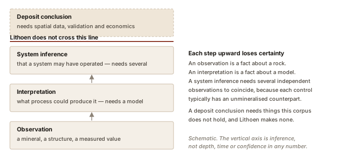
InferredMineralisation → deposit → resource → reserve: each step adds something Lithoen does not assert.
Mineralisation, deposit, resource and reserve are four different things. Mineralisation is the geological presence of concentrated minerals; a deposit is a body of it; a resource and a reserve are classifications that add economic and engineering judgement Lithoen does not make.
- method: Follows from the cited definition of ore, in which value and recoverability are explicit, combined with the system-versus-deposit distinction.
- precision note: Lithoen implements no resource or reserve classification framework and makes no statement in either category.
Evidence support: Supported by the cited evidence · 2 sources, multiple sources, independence unknown
Evidence: John 2010 · Primary authority; Geoscience Australia 2016 · Primary authority
EstablishedOre = concentration + value + location + recoverability under stated economic requirements.
Ore is not a purely geological term. The USGS porphyry model defines ore as rock in which the concentration, value, location and recoverability of the metal enable mining under predetermined economic requirements — so value and recoverability are part of the definition, not consequences of it.
- definition basis: The definition is quoted from a Tier A deposit model, not constructed by Lithoen.
- precision note: It follows that a mineralised body is not ore merely because it contains a useful element, and that Lithoen — which holds no economic framework — may not call anything ore.
Evidence support: Supported by the cited evidence · one source
Evidence: John 2010 · Primary authority
EstablishedPotassic, sericitic, advanced argillic, intermediate argillic, propylitic, sodic-calcic and sodic, greisen, skarn.
The alteration types recognised in porphyry copper systems are potassic, sericitic, advanced argillic, intermediate argillic, propylitic, sodic-calcic and sodic, greisen, and skarn.
Evidence support: Supported by the cited evidence · one source
Evidence: John 2010 · Primary authority
EstablishedMany features of these systems remain poorly understood as controls of ore formation.
The report states that the regional, deposit-scale and local-scale environments of porphyry copper deposits are diverse and that, despite much scientific study, many features are poorly understood in regard to their relevance as controls of ore formation.
- precision note: Recorded for the best-studied and most economically important mineral system on Earth, in the words of the model that describes it.
Evidence support: Supported by the cited evidence · one source
Evidence: John 2010 · Primary authority
EstablishedDisseminated and vein-hosted copper through large rock volumes around an altered granitoid porphyry.
Porphyry copper deposits consist of disseminated copper minerals and copper minerals in veins and breccias, relatively evenly distributed through large volumes of rock; host rocks are altered, genetically related granitoid porphyry intrusions and adjacent wall rocks.
Evidence support: Supported by the cited evidence · one source
Evidence: John 2010 · Primary authority
Model output3–5 wt%NaCleq
Fluids derived from porphyry magma at more than 1.4 kilobars have moderate to low salinity of about 3 to 5 weight percent before phase separation.
- model: USGS Porphyry Copper Deposit Model, which reports the value as a model attribute rather than a single measurement.
- system context: Single-phase magmatic fluid before separation into brine and vapour, in porphyry copper systems.
- conditions: Pressures above about 1.4 kilobars, equivalent to more than about 5 kilometres depth.
- precision note: Salinity is conventionally reported as weight percent NaCl equivalent, a recalculation rather than a direct measurement of NaCl.
Evidence support: Supported by the cited evidence · one source
Evidence: John 2010 · Primary authority
Model output0.3–2 wt%m Copper
The USGS model characterises porphyry copper deposits as low- to moderate-grade, in the range 0.3 to 2.0 percent copper.
- model: USGS Porphyry Copper Deposit Model, which gives this as a class descriptor.
- locality: The deposit class as a whole, not any individual occurrence.
- precision note: A descriptive attribute of the class in a published model. It is not a resource statement, not a reserve statement, and says nothing about any particular place.
Evidence support: Supported by the cited evidence · one source
Evidence: John 2010 · Primary authority
EstablishedUSGS Porphyry Copper Deposit Model (SIR 2010–5070–B), John and others, 2010.
This record represents the USGS Porphyry Copper Deposit Model, chapter B of Mineral Deposit Models for Resource Assessment, edited by David A. John with thirteen contributors and published in 2010. Lithoen represents that model and does not extend it.
- model: USGS Porphyry Copper Deposit Model, Scientific Investigations Report 2010–5070–B.
- precision note: A model is an interpretation of many deposits, not an observation of any one.
Evidence support: Supported by the cited evidence · one source
Evidence: John 2010 · Primary authority
EstablishedAlteration mineralogy detectable by infrared remote sensing.
Hydrothermal minerals characteristic of sericitic, intermediate and advanced argillic, and propylitic alteration, together with iron oxides and hydroxides and silica, can be mapped remotely through their distinctive absorption features in the visible near-infrared, short-wave infrared and thermal infrared.
- non uniqueness: The same alteration minerals are produced by hydrothermal systems that never developed mineralisation, and propylitic assemblages in particular are widespread and weakly diagnostic.
Evidence support: Supported by the cited evidence · one source
Evidence: John 2010 · Primary authority
Model outputMetals and fluids both derived from the associated magma.
The generalized model involves the interplay between magmatic metal sources and hydrothermal fluid systems, in igneous rocks related to one another geographically, temporally and genetically.
- model: USGS Porphyry Copper Deposit Model.
- component: Metals and ore-forming fluids.
- precision note: A generalized model, in the report’s own words; individual systems may differ.
Evidence support: Supported by the cited evidence · one source
Evidence: John 2010 · Primary authority
Established60 percent
Porphyry copper deposits account for more than 60 percent of annual world copper production and about 65 percent of known copper resources.
- precision note: The value carried is the production share, stated by the source as "more than 60 percent"; the resource share of about 65 percent is given in the statement.
- method: Reported by the USGS deposit model from published production and resource compilations.
Evidence support: Supported by the cited evidence · one source
Evidence: John 2010 · Primary authority
Model output1.4 kbar
The transition between single-phase supercritical fluid and separated brine plus vapour in porphyry systems occurs near 1.4 kilobars.
- model: USGS Porphyry Copper Deposit Model.
- system context: Magmatic fluid exsolving from porphyry plutons.
- precision note: A model boundary rather than a measured threshold; the report gives it alongside an approximate depth of 5 kilometres.
Evidence support: Supported by the cited evidence · one source
Evidence: John 2010 · Primary authority
EstablishedSubduction-related arcs, mostly — with real variety inside that, and poorer resolution with age.
Most porphyry copper deposits form in subduction-related magmatic arcs along convergent plate margins, in both continental and oceanic settings. Within those arcs deformation can be very complex and the deposits form in a variety of tectonic settings; some form in back-arc or post-subduction settings where, the model says, tectonic affinity is more poorly understood — especially for most Mesozoic and older deposits.
- non uniqueness: Subduction-related magmatic arcs are among the most extensive tectonic features on Earth and have been for most of Earth history. The setting is where these systems are found; it is not a place where one should be expected.
- precision note: The model adds that porphyry systems are widespread but seem to be localized in time and space within the evolution of an arc — which is a statement that the setting alone does not determine the outcome.
Evidence support: Supported by the cited evidence · one source
Evidence: John 2010 · Primary authority
Model outputExsolved magmatic fluid, initially supercritical, separating into brine and vapour as pressure declines.
Fluid-phase separation from porphyry magmas fractionates water, metals, sulfur and other volatiles out of the crystallising melt. Fluids leaving magma deeper than about 5 kilometres are a single supercritical phase of moderate to low salinity, around 3 to 5 weight percent, which separates into high-salinity brine and lower-salinity vapour as pressure falls.
- model: USGS Porphyry Copper Deposit Model.
- conditions: Above about 1.4 kilobars, equivalent to depths greater than about 5 kilometres, the fluid is a single supercritical phase.
- component: Water, metals, sulfur and other volatiles.
Evidence support: Supported by the cited evidence · one source
Evidence: John 2010 · Primary authority
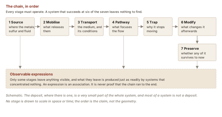
EstablishedThe system is the geosystem; the deposit is a small part of it that may or may not be present.
A mineral deposit is one very small part of a much larger geosystem. The signatures of a mineral system extend well beyond any deposit it may contain, which is why the system is treated as the larger target — Geoscience Australia applies the approach because roughly 80 per cent of Australia is covered by younger basins and regolith that obscure direct signatures. It follows that evidence for part of a system is not evidence that a deposit exists.
- precision note: Stated by Geoscience Australia in the context of exploration under cover. Lithoen records the scientific relation, not the exploration application.
Evidence support: Supported by the cited evidence · one source
Evidence: Geoscience Australia 2016 · Primary authority