Each claim states how it is known and cites its evidence.
Establishedan area observation with a reported possible tonnage; not a named object in the underlying exploration record
Reported for this deposit
A property of a dataset or model, shown here for context — not an observation about this record.
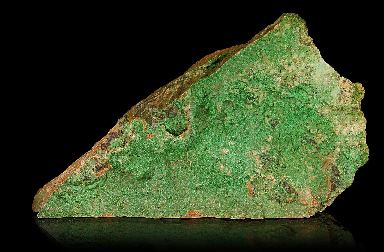
The nickeliferous clay near Central Bore, which the Geological Survey of Western Australia's 1984 bulletin heads as the 'CENTRAL BORE (MURRIN) DEPOSIT', is described in the exploration archive's own summary of the underlying report group as considerable thicknesses located IN THE AREA during exploration aimed at volcanogenic copper-zinc, nickel sulphide and asbestos, with a tonnage REPORTED AS POSSIBLE rather than estimated. The archive's list of prospects for that group names Crayfish Creek, Minara, Nangeroo, Randwick Hill, Rio Tinto and Murrin Murrin, and includes no Central Bore or nickeliferous-clay object. Two independent records — the survey's bulletin and the archive's summary of the source beneath it — therefore agree that the object is an area observation with a hedged conceptual tonnage, and the deposit heading is the bulletin's chapter organisation rather than a delineated body.
- assertion basis: SOURCE_REPORTED
- generality: DATASET_PROPERTY
- definition basis: What two records say about the firmness of an object, quoted rather than inferred. The archive summary is the Geological Survey's summary of a group of thirteen reports, not the company report itself, which has no public download route and was not read.
- locality: Near Central Bore, in the Murrin Murrin area about 55 km east of Leonora.
- assumption: This asserts nothing about whether nickeliferous clay is present in the ground, and may not be used to create, merge or delete any entity.
- temporal basis: The exploration is 1964 to 1983; the bulletin is 1984; the archive summary carries no date of its own.
Evidence support: Supported by the cited evidence · 2 sources, multiple sources, independence unknown
Evidence: Australia n.d. · Primary authority; R.J. 1984 · Primary authority
EstablishedAlmost all known deposits lie within 26 degrees of the equator.
Nickel-cobalt laterite deposits developed within 26 degrees of the equator, with few exceptions such as the hydrous magnesium-silicate deposit at Riddle, Oregon, and the deposits of the Urals, Greece and the Balkans.
- precision note: The exceptions are named by the source; a latitude band describes where the known deposits are, and the climate that formed them need not be the climate there now.
Evidence support: Supported by the cited evidence · one source
Evidence: Marsh 2013 · Primary authority
EstablishedConcentration by weathering: soluble elements leave, insoluble ones are redistributed and concentrated.
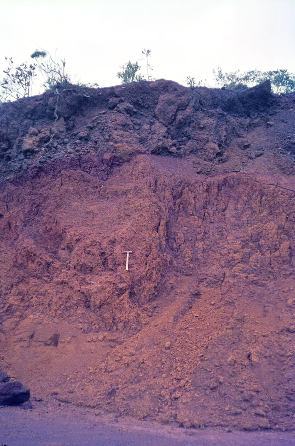
Nickel-cobalt laterites are supergene deposits formed by pervasive chemical and mechanical weathering of ultramafic rocks; the model describes laterite as a profile in tropically weathered regolith in which the most soluble elements are removed and the least soluble are progressively redistributed through a series of protoliths to form a concentrated deposit.
Evidence support: Supported by the cited evidence · one source
Evidence: Marsh 2013 · Primary authority
EstablishedRe-precipitation on saturation into hydrated alteration minerals, while magnesium and silicon are lost.
Nickel re-precipitates on saturation and is deposited with hydrated alteration minerals rather than remaining dissolved in the solution that leaches magnesium and silicon out of the profile.
Evidence support: Supported by the cited evidence · one source
Evidence: Marsh 2013 · Primary authority
EstablishedUSGS Nickel-Cobalt Laterites — A Deposit Model (SIR 2010–5070–H), Marsh, Anderson and Gray, 2013.
This record represents Nickel-Cobalt Laterites — A Deposit Model, chapter H of the USGS Mineral Deposit Models for Resource Assessment series, by Marsh, Anderson and Gray, 2013. Lithoen represents that model and does not extend it.
- model: Nickel-Cobalt Laterites — A Deposit Model, Scientific Investigations Report 2010–5070–H.
Evidence support: Supported by the cited evidence · one source
Evidence: Marsh 2013 · Primary authority
EstablishedProfile zoning is a solubility sequence, with secondary enrichment where pH rises at depth.
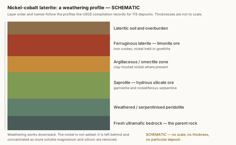
The zoning of a nickel laterite profile follows the solubility of its minerals. The most soluble, olivine and pyroxene, remain in the youngest and freshest part of the profile; the least soluble, goethite, makes up the most developed part. Increasing pH with depth allows elements to be deposited as secondary enrichments.
- precision note: The zoning records the order in which minerals dissolved, so a profile is read from the top down as a sequence of what has already been removed.
Evidence support: Supported by the cited evidence · one source
Evidence: Marsh 2013 · Primary authority
EstablishedUplift destroys the profile; tectonic quiescence preserves and extends it.
Laterites formed on accreted ophiolite sequences are limited by preservation potential in tectonically active regions, whereas those formed by weathering of cumulates in stable cratonic settings may be more laterally extensive, because the lack of uplift prevents mechanical stripping of the profile and allows a single planation surface to develop.
Evidence support: Supported by the cited evidence · one source
Evidence: Marsh 2013 · Primary authority
EstablishedNickel is inherited from the protolith, not introduced; weathering redistributes it.
The nickel is already in the protolith. Ultramafic rocks hold 0.2 to 0.4 percent nickel in olivine or serpentine, with nickel also present but less abundant in accessory pyroxene and chromite; weathering redistributes it rather than introducing it.
- component: Nickel.
- precision note: The abundance in the protolith is carried separately as a concentration claim on peridotite, where the ADR-0014 rule that a concentration sits on a material can be honoured.
Evidence support: Supported by the cited evidence · one source
Evidence: Marsh 2013 · Primary authority
EstablishedWherever ultramafic rock reaches the surface and the climate is right — active margins to stable cratons.
Nickel-cobalt laterites occur on presently active continental margins, in accreted terranes and obducted ophiolite sheets — New Caledonia, Moa Bay in Cuba, Falcondo in the Dominican Republic — in older accreted terranes and ophiolites such as Riddle in Oregon, and in komatiites and cumulates that are now part of stable cratons, such as Murrin Murrin in Western Australia.
- non uniqueness: This system spans the widest range of tectonic settings of the six, because what it actually needs is a protolith and a climate, and tectonics only controls whether the protolith is exposed.
- precision note: The clearest case in the corpus that tectonic setting is not the determining variable for every system.
Evidence support: Supported by the cited evidence · one source
Evidence: Marsh 2013 · Primary authority
EstablishedDownward percolation of meteoric water through the weathering profile.
The water responsible for laterite formation is circulating rain water and water within the water table; the percolating water travels the path of least resistance, relying on the crystal structure of the protolith and on inherited structure.
- conditions: Near-surface, ambient temperature, meteoric water within and above the water table.
- component: Water, nickel, magnesium and silicon.
Evidence support: Supported by the cited evidence · one source
Evidence: Marsh 2013 · Primary authority
Establishedtype A garnierite-dominated, type B smectite-dominated, type C oxide-dominated
How a source classifies it
General principle, shown here for context — not an observation about this record.
The Australian Geological Survey Organisation classifies nickel laterites by the mineralogy of the dominant nickel host into three types: type A, silicate deposits dominated by hydrated magnesium-nickel silicates such as garnierite and generally occurring deep in the saprolite; type B, silicate deposits dominated by smectitic clays such as nontronite and commonly occurring in the upper saprolite or pedolith; and type C, oxide deposits dominated by iron oxides. It defines the class as residual products of chemical weathering of olivine-rich cumulate rocks and their metamorphic derivatives with primary initial nickel contents of 0.2 to 0.4 per cent.
- assertion basis: SOURCE_CLASSIFICATION
- generality: GENERAL_PRINCIPLE
- definition basis: A classification by the mineralogy of the dominant nickel host, which the paper states is one of several schemes in use — others rest on host-rock alteration, climate, drainage, geomorphological history or composition.
- temporal basis: Published 1998.
Evidence support: Supported by the cited evidence · one source
Evidence: Brand 1998 · Primary authority
Establisheda nickel-rich regolith over a sulphide deposit is not a nickel laterite deposit
Reported for this deposit
General principle, shown here for context — not an observation about this record.
The Australian Geological Survey Organisation records that the regolith overlying matrix and disseminated nickel-sulphide deposits can also be nickel rich, naming Mt Windarra, Perseverance and Mt Keith, and states that so far none has been exploited specifically for its lateritic resources. Nickel enrichment in a weathering profile is therefore not by itself a nickel laterite deposit, and a sulphide deposit is not reclassified by the regolith above it.
- assertion basis: SOURCE_REPORTED
- generality: GENERAL_PRINCIPLE
- definition basis: The distinction the source itself draws when naming these three deposits inside a discussion of laterites.
- temporal basis: Published 1998.
Evidence support: Supported by the cited evidence · one source
Evidence: Brand 1998 · Primary authority
Establisheda known-deposit inventory conditioned by sulphide exploration history, as the survey states
Reported for this deposit
A property of a dataset or model, shown here for context — not an observation about this record.
The Geological Survey of Western Australia recorded in 1984 that little attention had until recently been directed specifically at prospecting for lateritic nickel deposits, that their distribution is certainly wider than the few investigated deposits it describes would imply, and that much of what was known came from exploration aimed at the underlying ultramafic rocks for nickel SULPHIDES. The known Western Australian lateritic inventory is therefore shaped by where sulphide exploration went, by the survey's own account.
- assertion basis: SOURCE_REPORTED
- generality: DATASET_PROPERTY
- definition basis: The survey's own characterisation of its inventory's completeness, not an estimate made here.
- locality: Western Australia, principally the Kalgoorlie, Leonora-Laverton and Ravensthorpe regions, with Wingelinna in the Musgrave Block named as the exception.
- temporal basis: Published 1984.
Evidence support: Supported by the cited evidence · one source
Evidence: R.J. 1984 · Primary authority
Establisheda deposit heading resting on a reported possible presence; ground once mapped as laterite reinterpreted as ultramafic caprock
Reported for this deposit
A property of a dataset or model, shown here for context — not an observation about this record.
Two Western Australian objects that later compilations carry as deposits are qualified by the sources that introduced them. The Geological Survey of Western Australia heads a section 'CENTRAL BORE (MURRIN) DEPOSIT' but reports only that Uren (1975) has described the POSSIBLE PRESENCE of a large deposit of nickeliferous clay, with a tonnage that COULD approach 100 Mt. And in the upper Bandalup Creek area the survey's 1998 report records that ultramafic caprock had previously been mapped as laterite. A heading and a compilation entry can both be firmer than the observation beneath them.
- assertion basis: SOURCE_REPORTED
- generality: DATASET_PROPERTY
- definition basis: Both statements are the sources' own hedges and corrections, quoted rather than inferred.
- assumption: This claim says what two sources say about the firmness of their own objects. It asserts nothing about whether either object exists, and may not be used to create, merge or delete any entity.
- temporal basis: Published 1984 and 1998; the Central Bore report it relies on is from 1975.
Evidence support: Supported by the cited evidence · 2 sources, multiple sources, independence unknown
Evidence: R.J. 1984 · Primary authority; Witt 1998 · Primary authority
Establishedsix names grouped under a deposit-type heading by a key that cannot distinguish deposit from prospect
How a source classifies it
A property of a dataset or model, shown here for context — not an observation about this record.
In 1990 the Geological Survey of Western Australia listed six named Western Australian objects — Yornup, Byro, Bandalup, Pyke Hill, Bulong and Wingelina — under the heading 'Lateritic nickel deposits' in the key to its figure of principal Western Australian nickel deposits by type. That key has no prospect class, so it labels every object it plots a deposit; it therefore records the deposit TYPE of each object and carries no information about whether each is a deposit rather than a prospect. The survey's own 1984 bulletin, which does draw that distinction within a single chapter, heads Yornup and Byro East as prospects.
- assertion basis: SOURCE_CLASSIFICATION
- generality: DATASET_PROPERTY
- definition basis: The names grouped under one class heading in one figure key. The key has no prospect class, so it labels everything it plots a deposit; it therefore carries no information about the deposit-versus-prospect boundary, and Bulletin 14, which does draw that distinction, heads Yornup and Byro East as prospects.
- locality: Western Australia.
- temporal basis: Published 1990. An inventory of what one survey listed at that date, not a statement that these are all such deposits or that each remains so classified.
Evidence support: Supported by the cited evidence · one source
Evidence: Australia 1990 · Primary authority
Established118,705 catalogue records; 53,393 flagged as having a digital file; no public route to report bytes
Reported for this deposit
A property of a dataset or model, shown here for context — not an observation about this record.
Western Australia's open-file exploration report catalogue held 118,705 records when read on 2026-09-09, of which 53,393 carried a digital-file indication. The catalogue publishes, for each record, a report-abstract page and a report-details page; it publishes no document download route, and the application's own search and download workflow requires authentication. The catalogue's metadata is open data under a Creative Commons Attribution licence; the exploration reports it describes carry their own separate rights, which this licence does not settle.
- assertion basis: SOURCE_REPORTED
- generality: DATASET_PROPERTY
- definition basis: Counts returned by the service's own returnCountOnly query on 2026-09-09. A digital-file indication is a catalogue assertion that a file exists in the archive; it is not a statement that the file is publicly reachable, and in this corpus it has never been shown to be.
- temporal basis: Read 2026-09-09. A live service; counts change as reports are released.
- assumption: This describes a catalogue. Nothing in it classifies a deposit, and a record's title, commodity field or digital-file flag supports no geological claim whatever.
Evidence support: Supported by the cited evidence · one source
Evidence: Australia n.d. · Primary authority